We started the hike and could go either towards Sherman Pass or towards Jungle Hill. We first headed towards Sherman Pass, then realized that was probably just going up to the highway. After walking for around half a mile, we turned around and went back. The other trail was 3.9 miles. Mostly uphill. Along the way, we kept running into bikers heading down the trail. We finally asked one of the guys and it turns out there was some festival going on. They all took a shuttle up to the top of Sherman Pass, then took one of the trails to the one we were on. So, they had a nice bike ride downhill the enture way.
We ended up hiking about 9 miles total. We're still sore. Afterwards we stopped in Republic to find dinner. There was a pizza and sandwich place and a Mexican place. Joe really wanted pizza and I wanted Mexican, so we had a small meal at the Mexican place, then Joe went back to get a pizza. We did some work and headed out to the next chunk of national forest to find a place to stay for the night. We ended up finding a road that dead ends and just stayed there. One neat thing was the stream that was nearby. Around it was filled with strawberry plants. Too bad most weren't ripe yet.
The next day we headed to Tonasket. We parked on the side of the street using someone's wifi, and got caught up with work. There was a small natural foods coop just a block away, so we did get some cold, fruit bars since it was incredibly hot. Our next plan was to head down a 41 mile national forest road (National Forest Development Rd 37) that goes through a pass that is around 6000 feet, so we knew we weren't going to have internet that night or the next day. We found a place to pull off and have dinner, but we didn't feel comfortable letting the cats out, so after eating, we kept going. It was already 8pm which made for a gorgeous view of the sunset behind the Cascades during our drive. We made it to the top and over. It was getting dark, so we found a spot to sleep for the night. The next morning, we left again and ended up finding a small road that went below the main road. It lead to, basically, a campsite right near a creek. The cats have been loving getting to spend the entire day outside.
We went for a walk this afternoon along the creek. There are two streams that meet where we are. One of them has a waterfall that Joe noticed. We decided to hike towards that. After getting across the stream, we heard Curly crying. We were worried he had tried to cross on his own, so Joe went back to get him. He was still on the shore, fortunately, but Joe grabbed him anyway and put him on his shoulders. Curly followed us throughout our walk. It was pretty fun. Even when we were walking in the stream, he followed us along the shore.
We are now sitting in Winthrop using some internet. It's a pretty cute town, though touristy. Once we get some work caught up, we'll probably walk around a bit.
-Miranda
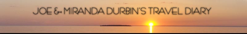
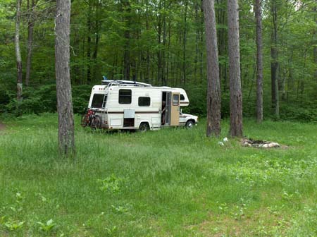
The place we stayed near the top of the pass.
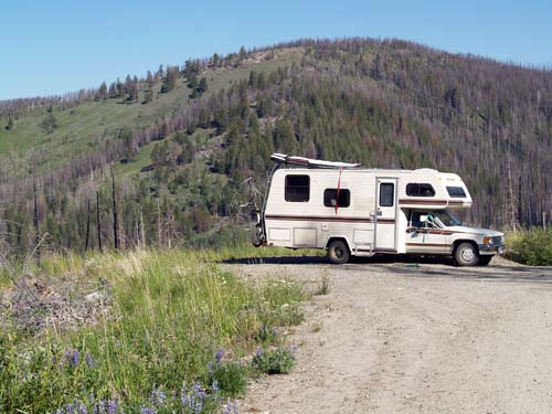
Our view from that spot.
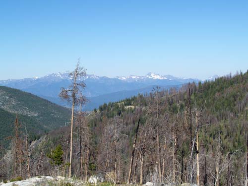
The creek right next to the spot we stayed at last night.
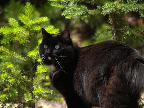
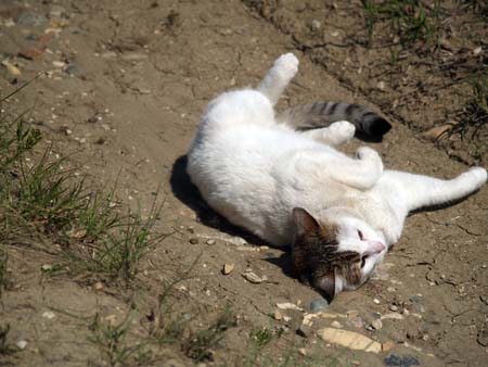
Finally got a decent photo of Zoe!
[ 2 comments ] ( 8 views )
We spent Monday running some errands in Coeur D'Alene. We mostly hung out in the grocery store parking lot, then a Target parking lot, working for a while. The plan was to just stay at a Walmart so we could get some work done.
For dinner we decided on sushi. There was a restaurant pretty much on the way. We stopped there and it was a pretty bad experience. There was one server and one cook. ONE COOK! She did all the sushi rolls and all the cooking. There were 3 groups there. We were the first and we almost got our food last after waiting for at least an hour. I ordered a sushi platter which was done at least 15 minutes before Joe's was. It was so weird. The cook didn't seem to know what she was doing. I ordered my stuff first, but both tables got their sushi before I did. Not that it really mattered in the end because it would have just taken longer for Joe to get his food. Pretty nuts.
We then headed straight to the Walmart in Port Falls, ID. We walked a little over a mile to a Dairy Queen. The next day we found an Indian restaurant in Spokane to have a good buffet at. The food was good.
On Sunday, after our walk, we were going to take a shower using the camp shower. Unfortunately, after setting it up, the branch it was on broke and the camp shower fell to the ground and completely split open. While on our way out of Spokane, we found a sporting goods store and bought another camp shower. Woohoo!
Until you get to Kettle Falls, there isn't much for National Forest. Near Addy, the National Forest did come up to the road, so we found some small roads that jutted off the highway. We checked those out and found one that was far enough off that we felt safe letting the cats out. They got to hang out, outside for a few hours. We just stayed there the night and we headed out right away in the morning.
We're now staying at a campground in Kettle Falls. The internet isn't great, but will work for tonight. We're not quite sure what the plan is from here. We may go back into town and just stay at the RV park there so we can have a good shower and good internet, or we may try the national forest across the lake to see if the internet there is decent enough so we can get work done. Who knows.
-Miranda
[ 1 comment ] ( 4 views )
After we left Sandpoint, we headed down US-95 and decided to check out a national forest near a lake. Google Earth said there was a campground, but we never know how accurate it is. Well, the dirt road we headed up to get there was pretty iffy, but got better so we kept going. Then there was a sign at a fork saying the campground was 1 mile down a hill. We knew it was down by the water, so we figured we would be going downhill, but there was a sign that said no motorhomes or trailers. Normally this means because there are no wide areas to turn around. It would have been nice if they had mentioned that the road wasn't maintained.... There were some pretty good ditches in the road, but nothing that we couldn't get past, it was a one lane dirt road with a wide spot every-so-often. We made it to the bottom. One side looked like parking for the water and there was yet another road going the other direction. We took that and got to a parking lot. Looking around, it was only tent camping (park, then walk to the site). So, we just swam to cool off then headed back up the hill. It definitely went better on the way out.
Leaving that area, we didn't want to completely rule out boondocking for the night, so we found another road to head down. The road was pretty decent until the fork we decided to try. Then it was definitely an old logging road. Unfortunately, one thing they do is dig a trench across the road for drainage. This isn't something that's an issue for a pickup, but with our long back end, it can be bad. Most weren't a problem, but we got to one that was too bad, so we got out and decided to see if it was worth it. Not too much farther, there was a large clearing and a perfect spot to stay. We went back and started working on cutting up some of the dead wood and even splitting some of it to fit into the ditch and drive over. Then once we drove over it, I put it on the back rack and we drove to the next one. We did that about 4 times before getting to the clearing. The spot is great. Definitely no one comes up here (it looks like it was cat loggers and the brush piles are already burned, everything's very overgrown) and we even have decent internet. It's not great, but it will work.
So, the plan is to stay here over the weekend. After all that work, we better be able to stay that long!
-Miranda
[ add comment ]
Sorry for not updating sooner. The mountains make for wishy-washy internet.
We aimed to leave Tuesday afternoon, but we didn't end up leaving until 7pm. We didn't get too far. There is a lot of national forest along highway 2, so we ended up finding a cute national forest campground near McGregor Lake and staying there the night. The lake was gorgeous. Super clear. It was pretty cold though, so we didn't go swimming.
We left in the morning and continued down highway2. We really wanted to find a boondocking spot since there was so much national forest. We found one road, parked on the side, then biked up it for 3 miles. Yes, biking in the mountains is not a ton of fun. At least not until the return trip. :D We didn't find anything up there, so we kept going. We found another small road nearby that ended at highway 2, so we headed down that. There was a smaller road that branched off from that. Instead of taking the bikes off, we took Curly out with us, and went for a short walk to see if there was a spot down there. Curly did really well, but we didn't find anything, so, back in the RV.
There was yet another road that branched off that one, so we headed down there and there was a nice clearing. The area wasn't perfect. You could hear the highway, but since it was early afternoon, the cats got to hang out outside for a number of hours. They were pretty happy.
It got hot though! No breeze. We had tons of extra solar though, so we pulled out the fan. We both ended up with headaches, probably from the heat.
We left right away in the morning and found a cute cafe in Bonners Ferry to have breakfast at. We are currently sitting in a parking lot in Sandpoint, ID working since the internet is decent.
So, we'll get some work done, and on the road again we go!
-Miranda
[ add comment ]
Well, we did end up staying at a rest area that night. It was a very small one, but worked out well. We left in the morning and decided to head for the National Grassland.
There were oil derricks everywhere, but we finally found a road that didn't have one at the end. We found a spot and pulled over, then let the cats out. The day was gorgeous, so we worked for a little bit, then decided to go for a bike ride farther down the road to see how it looked. The road ended at a large field that overlooked the nearby river. We walked down the hill to the river, then worked our way back up the hill to the bikes and back to the RV. Unfortunately, during that time, I got quite a nice sunburn on my back. Apparently I'm not used to that part being exposed now that I have short hair... Ooops.
The cats were super happy that they got to hang out outside a lot, so we stayed there the night. We left the next morning and kept working our way down Highway 2. We got to Havre, MT and stopped for dinner. After leaving there, Joe noticed some little girls standing outside on the sidewalk and realized it was an ice cream shop, so we stopped there and got some ice cream. We then continued on our way and made it all the way to the continental divide between East and West Glacier on the southern border of Glacier National Park. We stayed at a rest area there. The hope was to check out some of the forest this morning, but it was pouring last night and still pouring today, so we just drove on through and made it to Kalispell around 11.
We don't know how long we'll be here, but we have some work we want to do on the RV, so at least until that is done.
-Miranda
The spot we stayed at in the national forest in Minnesota.
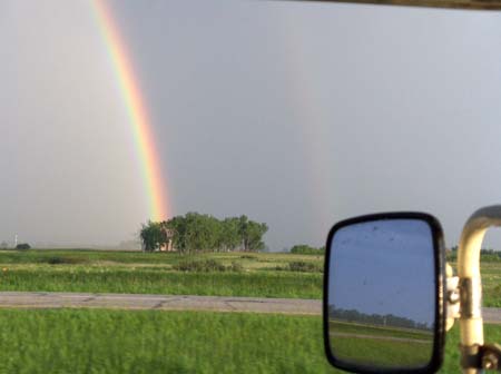
A double rainbow we saw while driving through the rain.
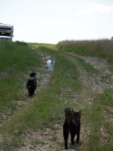
The kitties following us outside at the national grassland in North Dakota.
Happy Lucy.
[ 3 comments ] ( 20 views )
Back Next
 Calendar